SUE/SUM for Water Infrastructure
Harness the Power of Accurate Underground Insights for Effective Water Management
Building Resilient Infrastructure: Why Underground Mapping is the Key to Sustained Success
With investments in water infrastructure accelerating to replace aging systems and design new facilities, engineers and construction teams are breaking ground more frequently than ever. But too often, these projects are built on an incomplete picture of what lies beneath, inviting risk, design missteps, unexpected delays, and costly utility strikes during construction.
As buried utility systems become more complex and unpredictable, Subsurface Utility Engineering and Mapping (SUE/SUM) has proven to be an indispensable part of modern infrastructure planning. At DGT, we go beyond the basics of utility record research. With decades of real-world experience and a deep understanding of the intricacies of buried infrastructure, our team can identify hidden elements that others often overlook. This expertise provides accurate, comprehensive design plans—helping to avoid costly budget overruns, prevent damage to other critical networks, and keep water renewal and rehabilitation projects on schedule.
Optimizing Water Systems with SUE/SUM Expertise
Subsurface utility information is essential at every stage of a project, from planning and design to construction and maintenance. By delivering accurate, detailed data on underground networks, SUE/SUM professionals help prevent costly disruptions, streamline workflows, enhance crew and public safety, and support long-term sustainability—ensuring that every project phase runs smoothly and efficiently.
Improve risk analysis and assessments, addressing key aspects of water transmission and distribution
Utilize accurate data for water line failures and emergency excavation responses
Gain insights into water line depth to assess freeze concerns
Locate large water line leaks and identity potential voids and sinkhole
Enhance water line replacement projects with accurate surveys of existing conditions
Receive accurate data for GIS
Ensure safe and efficient project outcomes
Conduct rock and ledge profiling and detection of underground anomalies
Let’s Get Started
Speak with our underground utility mapping specialist to learn more about optimizing your next water infrastructure project using our SUE/SUM service offerings.
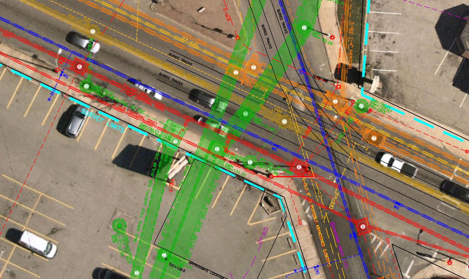
Showcasing Excellence: Applying Subsurface Utility Mapping for a Local Infrastructure Improvement Project
DGT partnered with Environmental Engineering Firm firm Wright-Pierce and the city of Fall River, MA, to address severe flooding in Stafford Square—an area increasingly impacted by climate change. To support the replacement of aging drainage infrastructure, DGT Associates provided a detailed utility map. In the final results, DGT revealed an array of underground obstacles, including abandoned utilities, historic streetcar tracks, and various underground anomalies that could impact the design and construction of the new planned drainage improvements. These critical insights will be instrumental in shaping the project results, offering designers and engineers a comprehensive understanding of both the surface and subsurface environments and enabling the development of more strategic, effective project plans.


Partnering with DGT for Subsurface Utility Mapping services was invaluable to our project’s success. Their mapping deliverable was high quality, detailed, and professional, giving us a clear and comprehensive understanding of the underground environment. With such critical insights, our team was able to make informed design and planning decisions, reducing risk and improving overall outcomes. The work was performed quickly and on schedule. We look forward to expanding our work with DGT on future projects.