Survey Mapping with Drones: The 200-Foot Perspective
Survey Mapping with Drones: The 200-Foot Perspective
There was a time, not so long ago, when the term “unmanned aerial vehicles” would spark both fear and wonder. These days, Unmanned Aircraft Systems (UAS)—best known as drones—are commonplace tools with a wide variety of applications, including surveying. According to a report by DroneDeploy, UAS technology applications grew by 239% in construction and 171% in surveying, just in 2018.
Particularly in surveying, drones have taken mapping services to another level of safety, flexibility, and efficiency. Drones allow surveyors to expand their domains and provide more value to developers, engineers, architects, and other industry professionals.
How Drones Provide a Value-Add in Survey Mapping
The applications for drones in surveying are almost endless: 3D laser scanning, façade mapping, site monitoring, as-builts, and even underground utility mapping using LiDAR systems. Drone work has also become increasingly popular as a cost-effective and work-efficient alternative to traditional aerial photography, providing low altitude flights and mapping of smaller areas. These flights can be challenging for larger manned aircraft to capture in terms of flight planning and project cost considerations.
In short, drones have elevated the methods and processes of data acquisition for surveyors, offering some key benefits:
- Safety: Because drones can be operated and adjusted remotely, they cut back on the need to have workers in dangerous conditions to collect data. Instead, the drones can be flown over challenging terrain, or around obstacles, while the humans continue their work from safe ground.
- Flexibility: On top of safety, UASs have made it easier for surveyors to map and collect data in hard-to-reach spaces. Since drones can be flown into areas that are inaccessible to humans, we can more easily capture every corner and crevice of terrain or buildings to construct comprehensive and accurate maps.
- Efficiency: Drones can simply fly faster than humans can walk, covering more ground and making for a faster process overall. The added safety and flexibility benefits only enhance efficiency. With the additional safety precautions and work-around methods for tight spaces, UAS technology has helped to shorten project timelines by allowing surveyors to collect data in a matter of a few hours instead of weeks.
Translating, Not Just Capturing, Drone Data
While the industrywide increase in drone usage has enhanced surveying work, the accessibility of the technology has also created disparate quality of deliverables. The barrier to entry for drone usage in surveying and engineering is low. Nearly anyone can learn how to operate a drone, but not everyone knows how to leverage the data correctly, and to produce accurate mapping.
In surveying and mapping, the level of accuracy is a key project consideration. Though drones may deliver clear pictures and can meet many project requirements, the data in the images may not always reflect the accuracy needed. With traditional ground surveys, we could measure features to fractions of an inch. Drone data measurements will inevitably be somewhat less accurate. But it has always been the responsibility of the surveyor to determine the accuracy of their work and to properly use the tools that will allow them to produce accurate results. As with any new tool, it is critical that the survey professional be fully trained in using the UAS to collect data, and the processing of that data, to produce data whose accuracy can be reported. For that reason, any contractor hiring someone who says they do drone work should carefully vet them to ensure that they have the right knowledge and experience to deliver accurate, usable maps.
Knowing how to not only collect data with drones, but also turn that data into reliable deliverables, takes knowledge and experience of photogrammetry, LiDAR, ground sampling distance, environmental controls, and relative and absolute accuracy. Contractors without adequate education and experience using drones in development work may not have the background knowledge to make the data usable. Capturing high-quality imagery has little value if the resulting project mapping is not produced properly by an experienced surveying and mapping professional.
Augmenting Plans with Orthophotography
At DGT, we use drones on many projects to enhance our survey plans with detail above and beyond what the CAD drawings can provide. The orthophotography produced with drone data capture provides detail beyond the lines on the virtual “paper.”
With UAS orthophotos, we’re able to include high-definition imagery of an entire site to augment our plans. Instead of only seeing a figure on a plan labeled “garden,” designers, owners, and builders can now see a real-life visual of the trees, greenery, and even flowers that they must work with on their site. A wide variety of site improvements, such as parking spaces, traffic markings, landscaping, tree lines, and water features, are presented in sharp, colorful focus.
“It makes our plans—to so many project team members—so much easier to understand, and therefore more valuable,” said John Lloyd, PLS, Regional Manager of our Worcester office. John oversees the majority of these projects as an FAA Certified sUAS Pilot and DGT’s UAS Director, applying his previous background in aerial mapping and deep knowledge of surveying and geomatics.
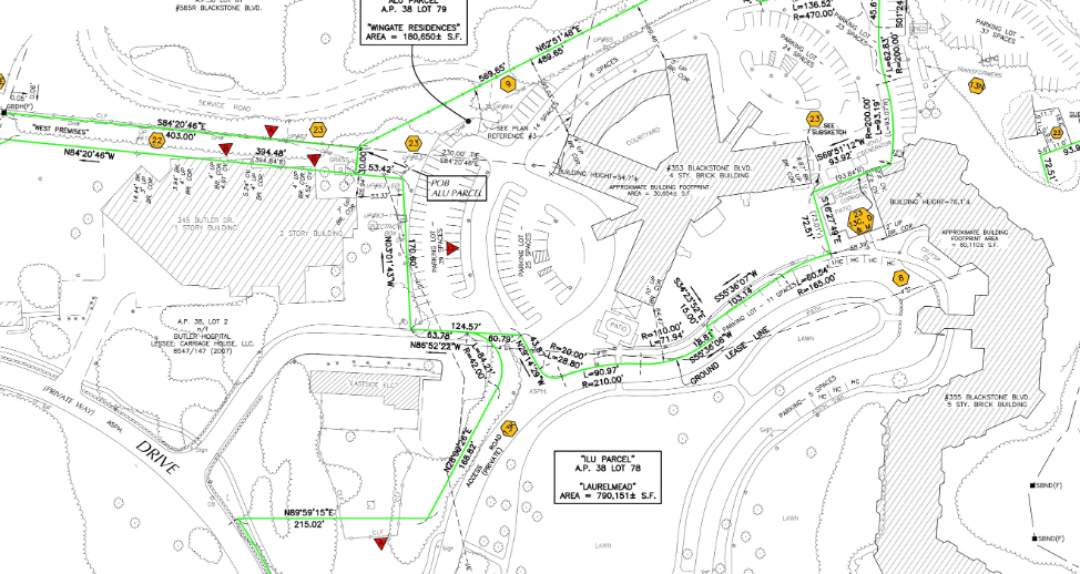
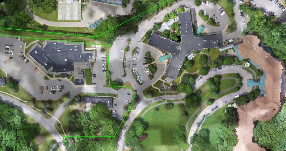
In the past year, DGT completed a comprehensive Land Title Survey of a nursing home care facility in Providence, Rhode Island. The figures below show both the traditional mapping and the corresponding orthoimagery. By including carefully processed imagery to the final mapping product, DGT provided value to the project that benefited the entire project team, engineers, architects, attorneys, and, of course, the client.
UASs have had tremendous impact on improving survey work. And with great power comes great responsibility. There is much knowledge and proficiency that should go into carefully using drones in survey work. But when used with skill, UAS can elevate survey work transforming today’s plans into visions for the future.
Learn more about DGT’s surveying and drone work.