Radar Tomography Explained: Advantages & Applications for Utility Mapping
Radar Tomography Explained: Advantages & Applications for Utility Mapping
Formalized underground utility mapping dates back as early as 1895 to construction of the nation’s first subway system in Boston. Relying on limited city utility records, the Boston subway designers quickly realized the lack of accurate underground plans and records exposed an enormous risk to the success of the project.
To overcome the ambiguity of underground site conditions, the transit design team dispatched survey teams to map the underground. Without today’s remote sensing technologies, survey teams had to rely on hand excavations and steam-powered earth moving equipment, called inclines, to expose underground utilities, basements, water reservoirs, coal chutes, and even tombs.


Today, Subsurface Utility Mapping (SUM) has progressed far beyond manual methods to reflect a different era of sophistication. New technologies have evolved to reduce the time and expense of utility surveyors digging up streets or tunneling under roads the way they did in the 19th century. While many utility surveyors still rely on utility pipe locating devices, often referred to as Electromagnetic Induction systems (EMI) and Pushcart Ground Penetrating Radar (GPR), they have begun to incorporate modern utility-locating technologies, such as Radar Tomography (RT).
Evolution of Radar Tomography
While radar tomography—a data acquisition method combining large arrays of GPR antennas with unique post-processing software solutions—is not new to the industry, what is new, is the various forms and levels of accuracy. The first time GPR was used in the subsurface environment was to investigate the depths of glaciers in the 1950s. Nearly 20 years later, once technology became more affordable and commercially available, use cases began to expand and the level of interest skyrocketed. Today, GPR is most commonly used as a noninvasive technique to map, measure, and visualize structures buried beneath the surface. Geology, mineral exploration, and archeological investigations provide the most traditional use cases for GPR, but more recently subsurface utility investigations have become another popular application. Software using GPR technology allows unknown or undocumented assets to come to life on a computer or tablet screen.
Radar tomography builds on GPR advancements by applying multi-frequency GPR antennas of various frequencies, or stepped frequencies, in a single device to investigate large areas with greater speed and detail compared to traditional push-cart devices. In many instances radar tomography systems have been incorporated into mobile-mapping platforms, aboveground lidar technology, thermal imaging, and laser imaging systems to allow the collection of millions of data points within seconds. For example, radar tomography systems can be attached to moving vehicles, replacing unsafe methods such as crews using walk-behind pushcarts to locate and map underground streets. The need for extensive traffic control measures or expensive lane closures and traffic flaggers is negated. With a sophisticated radar tomography system, utility surveyors can collect exponentially more data in less time than when compared to traditional pushcart mapping. Another benefit to radar tomography is that it allows for greater detail and accuracy in depicting precisely what’s below the surface.
Application of radar tomography results in highly accurate, comprehensive, and consolidated plans that both asset owners and developers can use to safely move forward. Radar tomography for underground mapping is often overlooked in favor of less expensive, far less accurate, options, as is common with most new technologies. Project owners, today, still rely on a simplistic approach via free requests to the One Call system (referred to as Dig Safe in New England), paint markers on-site, or outdated utility records. But, what happens when surprise discoveries are made during excavation? In many instances, failed utility locating practices lead to project delays, service disruptions, costly mistakes, and fatalities.
DGT’s Underground Locating Process with Radar Tomography
To avoid costly and devastating locating errors, DGT takes a holistic view of underground mapping. We incorporate a multi-step approach to utility locating. As our clients continue to become aware of the benefits, radar tomography is increasingly employed to confirm what we know about asset locations and to discover potential unknowns before the planning and digging of a site begins.
During the first phases of a project DGT gathers utility records. Often times pulling utility information from our extensive library of records—which we’ve accumulated from our legacy firms’ files and our own 25-year history. We supplement this data with new data obtained by contacting public and private asset owners. Old records are then digitized, data is geo-referenced in CAD, and pertinent information is color-coded to define the various types of utilities—gas, water, telecommunication, and so on—in accordance with APWA color-coding.
While record collection is a helpful first step, we don’t recommend stopping there because record compilation rarely communicates the whole picture. New mapping technologies and techniques, in combination with hand-held instruments, compile additional details and increase precision. Wearable mobile mapping is another method growing in popularity. Our laser-scanning professionals utilize nimble devices, such as NaVvis VLX, to capture tight spaces—both indoor and outdoor—that may otherwise be inaccessible.
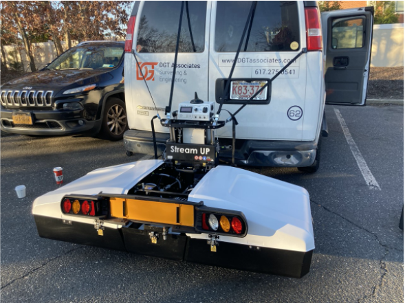
For projects requiring larger data collection over larger areas, DGT utilizes mobile radar tomography systems like 3D Radar and IDS Stream Up. The 3D Radar ground-coupled system is pulled by a fiberglass trailer and uses a step frequency set that transmits an energy wave into the ground at 200 MHz to 2000 MHz to create real-time data sets; imagery that can be seen instantaneously on our screens. This wide frequency band results in a high resolution and high data quality of complex utility structures. Post-processing interpretation software within 3D Radar allows for clear control of processing steps, simple data manipulation, and annotation. When the data set is overlain onto existing digital records, gathered in phase one, a comprehensive picture begins to form.
Radar Tomography in Action
Recently, DGT was tasked with gathering landside subsurface utility information for a wind farm project in New York. The wind turbines will require new lines be laid at the bottom of the ocean, which will re-surface through a trench in a beach community on Long Island. From that point, there is a 17-mile route—a perfect candidate for radar tomography—needed to connect and transfer the collected energy into a substation in South Haven. To get the green energy from point A to point B, project owners need to build a route that will safely transfer the collected renewable energy without disrupting any existing utilities.
Originally, the project owners believed they would be able to gain participation from underground asset owners and determine a clean line for the transfer of power. After two years passed with low participation and response, the owners realized the baseline records they had would not be enough to safely move into the planning and design phase. DGT was hired to locate utilities using IDS Stream Up, collect data, and post-process the data so the project owners could correlate findings with the limited underground records available. Once DGT provides the utility findings, the project designer will analyze the utility infrastructure, perform a risk assessment, and recommend the placement of the pipeline. When the project is finalized, the new turbines are expected to have the capacity to power more than half a million homes in New York State.
Retracing History
While the Boston subway designers were among the first to realize the importance of locating and mapping the underground environment, they were not the last. Remote sensing technologies have become a part of everyday use in SUM projects. Their uses may vary depending on regions, complexity of the work, project budgets, and the risk owners are willing to accept, but the benefits are clear. Hopefully, one day, every underground utility will be properly marked to create a safer aboveground environment. Far-fetched? For now, we’ll keep pushing boundaries.
To learn more about our radar tomography capabilities, contact Mike Twohig, DGT’s Project Director for Subsurface Mapping.