Surveying R&D: Technology Ingenuity Lies Within
Surveying R&D: Technology Ingenuity Lies Within
In an ever-changing digital world, every aspect of our lives and our work has changed.
Particularly in the surveying and engineering fields, our work, workflows, and instruments have been impacted by digital transformation—transformations that have altered how we communicate, how we collect, store, and share survey data and deliverables, and the fundamentals of how we approach much of our survey work.
Most of the technological advancement through the years has been led by “technological” firms—some small firms that have become behemoths, some large organizations that acquire the small firms. These creators of new hardware and software products find new ways to improve everyday tasks in our work.
But they aren’t the only ones who can. Surveyors, who know the challenges and nuances of being in the field best, can and should join in as leaders of the technological advancements that continue to drive the survey field forward.
New Technologies Through the Years
For utility surveyors and land surveyors, technological change has happened often in ways we have not expected. For example, surveyors did not imagine how large an impact drones and various LiDAR technologies would play in surveying large and inaccessible areas. These technological improvements have made an industrywide positive impact by minimizing the time and risk of surveyors being in harm’s way, both above and below ground.
We see cloud-based solutions helping teams capture data and making it possible for office teams, managers, and clients to see the progress of field data capture in real time. We have also witnessed the advancements of wearable devices that allow technicians to capture more data in the field and glasses that allow us to visualize the digital world merged in mixed reality. These are all truly amazing progress in just the last few decades.
The Challenges of a Cornered Market
While these amazing technologies come from all over the globe, there are only a dozen major organizations that dominate the available geospatial technology. Despite the benefits of improved and more robust geospatial tools, there is a downside to the majority of instruments, hardware, and software coming from global corporate giants.
The first impact we see is the escalating costs for many of the tools we use. Additionally, the rapid technological advancements mean there is a shorter life cycle for many of the survey tools. In fact, it is not hard to find some systems not being supported in just a few years of work. Another change not suited to all customers is the switch to subscription-based models for the purchase of software systems, and in the not-too-distant future, hardware systems. This means that in the coming years we will see the major firms only selling supported product lines through subscription services, and all other systems will be unsupported and obsolete. While the mega geospatial sales team will disagree, it is the sad truth. Some survey professionals will be unaware of these business models and embrace new technologies that continue to emerge, while seasoned and more traditional geospatial professionals will be aggravated with the change.
Innovation from the Inside
Though surveyors may be reliant on the technology available, what if the mega geospatial firms aren’t making the tools many of us see in our future? What if the future of survey technology can be accelerated by the ideas of those who know the industry’s needs best? Ingenuity and a bent for the right tools to get the job done have long been a part of a surveyor’s principles. While leaning on today’s tools, surveyors have the opportunity, and responsibility, to push for innovation toward tomorrow’s challenges.
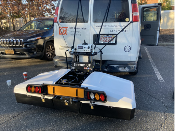
DGT has long envisioned an integrated mobile mapping platform that can capture above- and below-ground data to provide an alternative survey approach to longer projects as well as projects in busy thoroughfare and environments that are not conducive to drones. Yes, many of the mega firms make some components that could be used in mobile mapping platforms, but these are often cobbled-together solutions that lead to more subscription contracts.
Seeing opportunities for further innovation, DGT has chosen to take the very best trusted technologies from some industry-focused providers combined with new systems from new technology experts to take subsurface utility mapping to another level for our clients. And we encourage other surveyors to adopt the same mindset. We recognize that the expensive part of R&D is often a luxury for mega geospatial firms, and smaller firms can’t always foot the bills. But we at DGT have embraced today’s technological and financial challenge to finding a solution to meet geospatial challenges. In the long run, we’ve found that internal R&D always pays off.
New survey approaches aren’t just about shiny new toys. New technology provides an opportunity to educate clients on what alternative data capture systems can provide and ultimately deliver them a better product. Additionally, continuous technological innovation in the field will attract a new generation of young talented geospatial teams to the industry.
While the mega firms will continue with their world of monthly subscriptions and being the “middleman,” DGT sees the creation of a mobile mapping platform as a way to create new highly skilled, highly structured teams of professionals that can capture, process, and share more data in real time and work in an industry with true succession planning for those motivated, creative, and data-driven professionals.
Read about the benefits of radar tomography mobile mapping platforms. And stay tuned for the announcement of a new DGT-owned system.