Augmented Reality and 3D imaging: An exciting new dimension
Augmented Reality and 3D imaging: An exciting new dimension
For centuries, surveyors and engineers have used maps and schematics to understand subsurface utilities before, during and even after their work, both to ensure project success and also to ensure the safety of the workers involved. In Massachusetts alone, land surveyors have been locating and mapping buried facilities and underground structures for over 125 years. Yet that work, which once was the domain of paper maps and charts, is taking enormous leaps forward thanks to advancements in the use of augmented reality and accurate 3D imaging, which now allows us to see what’s beneath our feet without even picking up a shovel.
Data Collection – Then and Now
When we look back at historic survey plans and records, the quality and workmanship in the deliverables is consistently impressive despite slowly-evolving methods of data collection and visualization. Color-coded plans prepared by professional drafting teams presented the survey results in intricate detail based on site surveys, above and below ground. In many instances, the cross-section of buried structures were surveyed from open excavations and test-pitting work to capture precise real-world measurements needed for civil designers and engineers to make informed decisions. Mobile, steam-powered “incline machines” and hand excavation techniques were frequently used to expose buried assets to enable surveyors to locate the underground world. In an overpopulated and crowded city, there were occasions when tunneling under the streets to map the buried lines was necessary to mitigate the impact to pedestrian and streetcar traffic — an undertaking that may seem extreme to modern professional SUM practitioners.
In ages past, that type of manual work and limited depiction was simply the only way to properly create meticulous subsurface utility plans that documented the locations of utilities, foundation elements, basement walls, underground vaults, tunnels, and in some cases even tombs.
The importance of that work is not going to change. The way we achieve the necessary knowledge, however, is evolving at a rapid pace. Advanced technology like augmented reality and wearable devices that give highly accurate real-time 3D pictures of underground infrastructure is the next frontier for subsurface utility mapping professionals.
Rapidly advancing technology
Today, survey professionals incorporate the latest in remote sensing and geospatial technologies to improve the way we deliver data. Augmented- and mixed-reality solutions are emerging as the newest innovation in our quest to accurately and efficiently visualize above and below ground data. At the recent CGA Conference and Expo, Alec Pestov of vGIS presented a solution that uses data collected by practitioners like DGT Associates, and creates a clear 3D picture using Microsoft’s Hololens technology to help asset owners and designers make informed decisions, whether they’re viewing plans from their office or are actually walking around on site.
“It’s a cloud-based system that combines information from multiple sources at the same time,” Alec says. “It reaches out to Google Maps, Bing Maps, Esri Maps, OpenStreetMaps, client GIS databases and other components to combine them into visuals on the fly and push them down to the device.”
Just as with the old-school methods of location and mapping, it all starts with the data. Most municipalities will have extensive records of their utilities and other assets, and it’s a surveyor’s charge to make sure that data is collected and organized with precision. From there, the vGIS system can convert all of the data into a meaningful, understandable picture that can be viewed using the Hololens, or even on a mobile device like a tablet or smartphone.
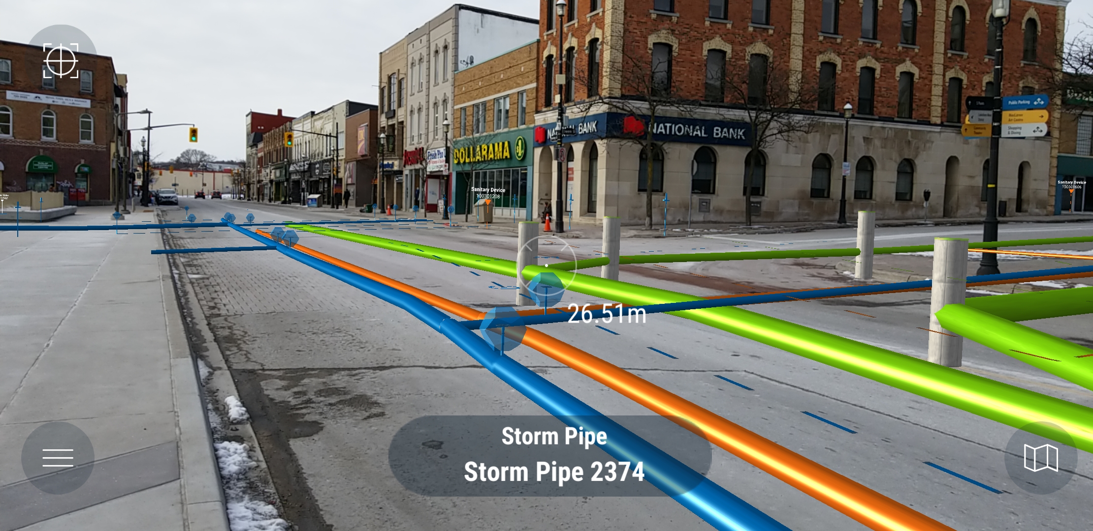
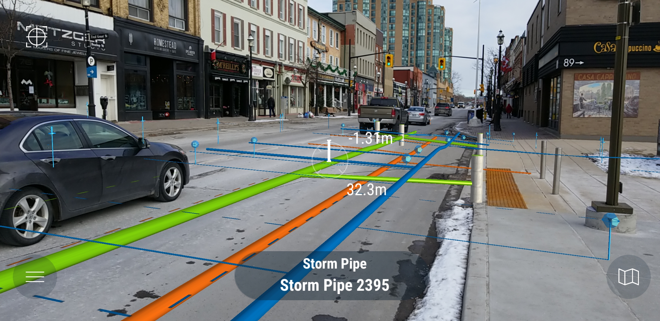
How 3D visualization works in the real world
Reading paper maps and schematics always required a bit of imagination from the reader to visualize what each piece would look like under the ground. With the development of augmented reality technology, rather than having to look at a map and calculate what two-dimensional drawings mean in the real world, the user can put on a visor or pull out a smartphone and walk around the site, looking down at the ground and seeing a color-coded projection of the actual lines are beneath their feet.
“What our system does, it taps into the asset databases, and it brings the data into augmented reality view,” Alec says. “The system doesn’t expose what doesn’t exist, but instead it connects to what’s already out there, and gives different views to the existing data sets.”
The accuracy of the picture and the novelty of being able to see a 3D picture of underground utilities in real-time are great benefits to working with this new technology. But it’s not just a gimmick — one of vGIS’s clients estimated that it saved 12-20 hours per person per month due to the efficiency of using real-time 3D visualization in place of paper records.
Alec cautions that users should have reasonable expectations when it comes to the sophistication of current-gen technology. Users should not expect dazzling, Hollywood-quality special effects, but the graphics and interface are a step ahead of where they once were.
“When the first iPhone came out in 2007, looking back, it wasn’t a great product,” Alec says. “It was an awkward device. But once they went to the iPhone 3G, it had access to the faster networks so you could use some of the data services, you could use some of the applications and the App Store. What seemed like a small improvement to existing hardware became vastly more useful. With augmented reality, we’re at that stage. We’re at the stage where it can actually work for the early majority, rather than the early adopters. The companies that start adopting the tools right now will have an edge over companies that start three, four, or five years down the road.”
At DGT, we are are proud to partner and work with Alec. We’re always interested in finding ways to do our work better and more efficiently, and the benefits we see from augmented reality products like vGIS’s will take our industry in a bold new direction – one where we’re not limited by our own imagination.