Radar Tomography: Enabling Accurate, Safe, and Cost-Effective Mapping on Highways and Beyond
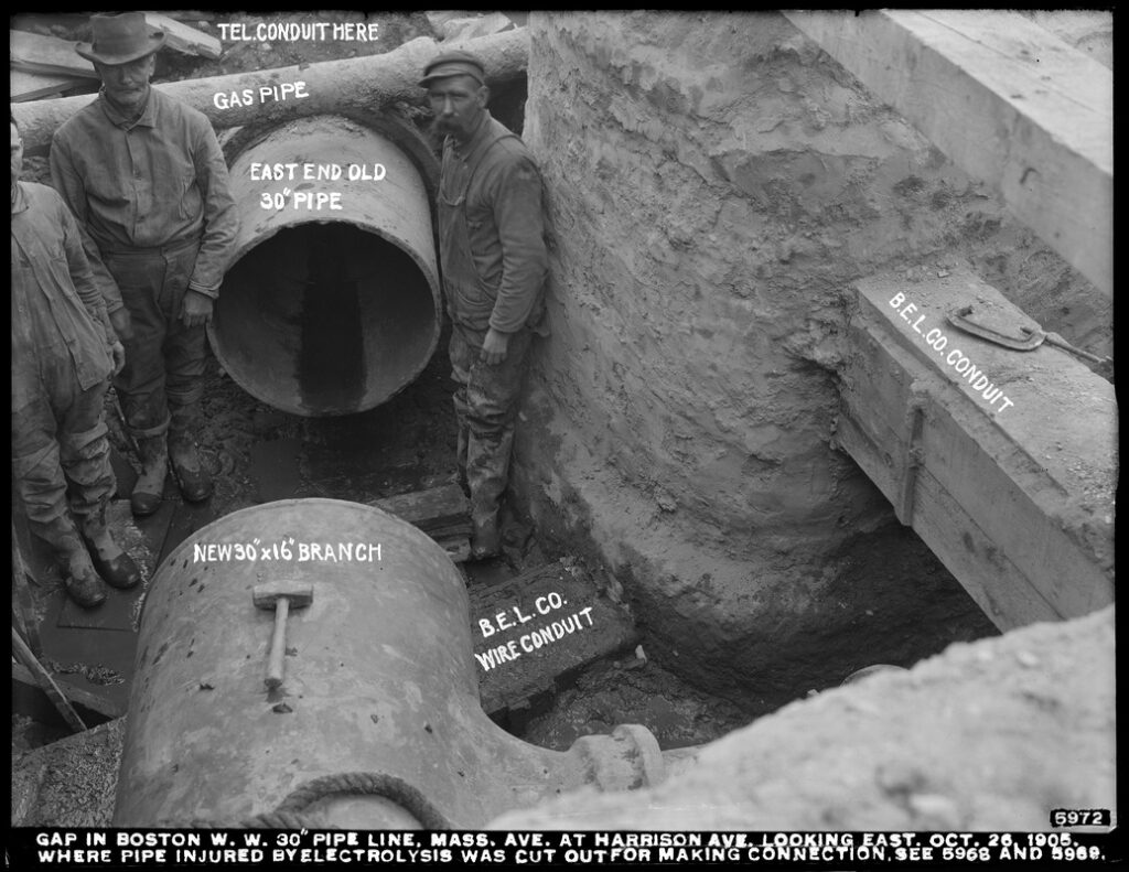
The practice of mapping underground utilities can be traced back more than 125 years to a team of designers working for the Massachusetts Transit Authority on an unprecedented endeavor through the winding streets of Boston. While working on the project, which would eventually become the first subway system in the United States, the designers recognized that there was a lack of accurate information for the existing buildings and underground facilities along the proposed project path. To gain a deeper understanding of the subsurface environment and project site, the design team embarked on an extensive underground investigation that included soil, utility, building, and archeology investigations in unison with topographic surveys. As a result of our predecessors’ preliminary design work, “America’s First Subway” was born.
The creation of the subway system in Boston inspired other U.S. cities to follow suit and invest in various modes of transportation to meet the needs of their growing populations. Today, 94% of transportation in the United States occurs via highways and interstates. Due to the high demand, both initial project planning and regular maintenance are critically important to keep these infrastructure systems operational and safe. Modern mapping technologies, such as radar tomography, provide the opportunity for a higher degree of project accuracy, efficiency, and safety during infrastructure projects for highways, interstates, bridges, and more. As President Biden’s $110 billion infrastructure law comes to fruition, it’s more important than ever for industry practitioners to look to Subsurface Utility Mapping (SUM) and additional modern mapping technologies to create a sustainable infrastructure system that can withstand the test of time.
Creating a Higher Quality of Work: Radar Tomography
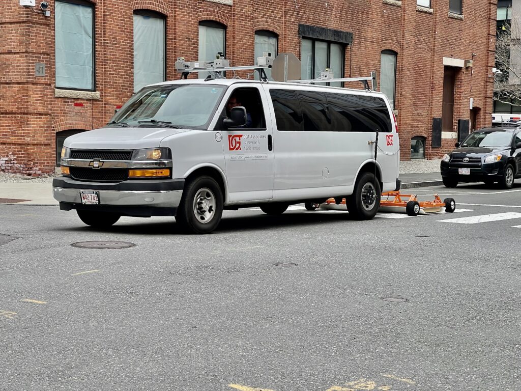
One of the most significant advancements in modern utility mapping has been the creation of mobile mapping platforms, including radar tomography. Traditional surveying methods, such as total stations, are feasible for aboveground surveys but not below. Mobile mapping systems have the capability to collect vast amounts of underground data at much higher speeds than other data collection methods, such as pushcart systems. What mobile mapping can collect in days would take other methods weeks to collect. Mobile mapping platforms can also upload data directly to a digital environment so that designers can visualize the project, enabling them to make informed decisions about their work during the preliminary stage.
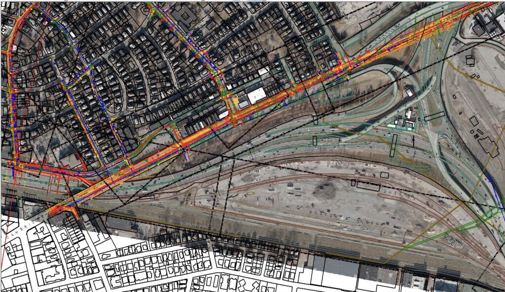
With many local and national governments looking to address climate change and the consequential adverse effects of powerful weather events, such as Hurricane Irma washing away parts of a highway system in Florida, building robust infrastructure systems is paramount and having up-to-date records is crucial. It’s also important for decision makers to understand the vulnerabilities of existing infrastructure so that they can plan restoration efforts prior to their expiration date or damaging seasonal weather events. When a devastating weather event occurs, it often leaves the built environment unsafe to visit, making a detailed 3D view of the infrastructure an extremely powerful tool for stakeholders. Luckily, modern technology has made capturing and mapping that data an easier and safer task. Radar tomography via a mobile mapping platform can provide that accurate 3D view in an accessible online format, all while keeping surveyors safe in a vehicle and with minimal disruption to the surrounding traffic and communities.
Ensuring the Safety of Our Crew: Radar Tomography
For any project, ensuring a safe work environment for crews is essential. With traditional SUM methods, such as pushcart systems, crew members are exposed to the hazards of the roadways. Arguably, the most important feature of mobile mapping systems is improved safety standards for utility data collection, especially in high-traffic, fast-moving areas such as highways. According to a report based on data from the U.S. Occupational Safety and Health Administration (OSHA), almost 40% of pedestrian fatalities in work zones were on-the-clock employees primarily engaged in utility and surveying work. Despite the industry’s best efforts to keep crews safe with traffic detail and closed work zones, the reality for practitioners is that the proximity to traffic, even on private property, is more dangerous than ever.
With only a few traffic cones and orange signs placed on-site, professionals have little to no protection in these danger zones. Even during the initial wave of the COVID-19 pandemic when a majority of the population was staying at home, some states saw an increase in the number of work zone crashes. Why? Drivers made the poor assumption that fewer cars on the road meant they could drive at higher speeds. In drastic comparison, mobile mapping systems are more likely to travel on roads at reasonable speeds without completely closing lanes, keeping a new generation of geospatial professionals safe.
Time Is Money: The Cost Benefits of Radar Tomography
While the cost of utilizing a mobile mapping system may be an initial concern to project managers, it’s important to take into consideration the cost savings from overhead, traffic control planning, permits, lane closures, traffic flaggers, police detail, and more. For example, on a project site, using a mobile mapping system has the potential to reduce around 10% of vacuum excavation holes which traditionally drive up project costs and roadway disruptions. These high-tech mapping systems can reduce project costs by thousands of dollars.
Additionally, if project owners do not perform their due diligence and strike a utility, the cost implications is potentially devastating. Striking a utility in the United States costs an average of $4,000, not including the additional fees for traffic control, equipment rental, hiring lawyers, etc. According to a study conducted by the Infrastructure Protection Coalition, damages to public infrastructure and time wasted during underground utility projects account for $61 billion annually. Considering the cost of correcting these unnecessary damages, gathering underground utility data via radar tomography prior to construction seems like a no-brainer.
Investing in the Future: Mobile Mapping Platforms
Commercial mobile mapping platforms have been around for over a decade and are commonplace on vehicles, drones, and even boats. Despite the technology being around for so long, positioning, correlating, and ensuring that sensors work in unison on collection vehicles is not an easy task. In fact, positioning mobile platforms in urban environments can be as difficult as positioning them in canyons. Because of the nuances within cities and with modern technology, it’s important to partner with an experienced firm that can provide detailed results. At DGT, we’ve invested in modern technology, like our mobile mapping platform, because we understand the value and know that to maintain best practices we must optimize how we collect data.
As leaders in the industry, we’re a long-standing advocate for underground mapping during the preliminary design phase of projects, and we’re beginning to see rules and regulations shift in favor of our beliefs. For example, legislation in Colorado requires all Subsurface Utility Engineering (SUE) projects to achieve an ASCE 38 Quality Level B depiction, and if that’s not possible, they must provide reasonable rationale and documentation. Similarly, in our home state of Massachusetts, the Massachusetts DOT now requires “the performance of SUE Level B services by qualified engineering firms during the preliminary design phase for all new projects anticipated to involve subsurface utility relocations.” As safety requirements become more widespread throughout the country, it’s up to industry professionals to continue innovating and modernizing our craft while creating and implementing best practices.
Innovation Stemming from Tradition
More than 125 years ago, our peers recognized the need for accurate, up-to-date geospatial information for infrastructure projects. While the data collection procedures and technology for underground mapping have changed, the need has not. As we continue to revolutionize technology within our industry, we remain hopeful that our impact will allow future generations to view us as we view the practitioners who created the first subway system—detailed, innovative, and forward-thinking.