Campus Planning
Uncovering a Wealth of Knowledge With Geospatial Technologies
Future-Proofing Campus Investments: Why Underground Utility Mapping Matters
As hubs of learning, colleges and universities have designated succession plans for all important aspects of their institution—leadership, faculty, endowments, curriculum—but often neglect plans for the campus itself. Comprised of comprehensive maps of the above and below-ground environment, a digital utility atlas can ensure that future generations of facility managers and relevant contractors are equipped with the necessary information.

Starting Your Campus Planning Journey to Create a Digital Utility Atlas
DGT Associates is a premier surveying firm with decades of experience mapping above and below-ground environments. No matter the state of your campus and facility records, we offer diverse geospatial services to meet your unique needs. While every campus is different, building a comprehensive subsurface utility atlas is very important.
01
Define a Standard of Care
DGT will help define a standard of care for mapping the underground for CAD or GIS platforms.
02
Begin Record Collection
DGT collects and correlates your utility records into one digital file that meets the American Society of Civil Engineers, ASCE 38-22 underground mapping national standard.
03
Execute Underground Utility Mapping
DGT will help your team decide on the appropriate technology application and leverage the power of modern remote sensing technologies, such as Electromagnetic Induction (EMI) pipe locators and Ground-Penetrating Radar (GPR), acoustic systems, and thermal imaging to discover underground networks.
04
Build a Comprehensive Digital Twin
DGT provides a comprehensive utility survey that can be used to create a searchable, single-source digital utility atlas
Support Succession Planning for Facility Managers
Implementing a digital utilize atlas on campuses creates a digitally documented single source of truth and contributes to a safer, more sustainable, and better-managed educational environment.
Tailored for succession planning and knowledge transfer
Improved efficiency for facility departments
Accurate underground data to the same level of accuracy as the above-ground built environment
Enhanced communication for critical infrastructure
Heightened campus safety
Realized cost savings related to utility and underground risks
Creating a Successful Subsurface Utility Mapping Program
Following ASCE 38-22 utility engineering standards, DGT offers four levels of mapping data to meet your mapping and budget goals.
Proprietary and public utility records are gathered to understand your site’s evolution and history. Quality Level D offers a lower financial investment.
A ground survey of utility hardware is performed to augment existing records.
Buried utilities are traced and marked using the appropriate geospatial technology. Data is collected by a mapping professional, and results are transferred to CAD or GIS platforms. The results can be uploaded to mobile or wearable devices for easy access and retrieval.
The highest level of mapping detail utilizing vacuum excavation and offering intel into pipe sizes, elevation, material, and condition of utilities. The only level that provides vertical and horizontal location information of utilities.
Cutting Edge Technology and Equipment
DGT is one of the only nationwide geospatial firms that owns and operates advanced remote sensing technologies, enabling our team to capture large project areas daily.

Remote Sensing Technology and Mobile Mapping
Minimizes disruption to pedestrian and vehicular traffic on campuses while extracting high-definition images of the underground. Our technology includes pushcart GPR systems, mobile mapping GPR, EMI (traditional pipe locators), and more.
Radar Tomography
Minimizes disruption to pedestrian and vehicular traffic on campuses while extracting high-definition images of the underground. Our technology includes pushcart GPR systems, mobile mapping GPR, EMI (traditional pipe locators), and more.


3D Imaging and LiDAR Systems
3D scanners capture a 360-degree picture of the above-ground environment to provide context for underground mapping.
Aerial Imagery
DGT combines imagery with our utility mapping to add perspective and ‘ease of use’ for our clients.
Did you know?
While many underground mapping providers paint and flag underground systems, it is often a visual nuisance. Paint and flags are essential for excavators but unnecessary in the mapping of underground systems. DGT advocates for facility managers to incorporate 811 best practices into underground damage prevention programs and incorporate OSHA and CFR regulations into more robust underground protection initiatives.
Digital Utility Atlas Applications
Following ASCE 38-22 utility engineering standards, DGT offers four levels of mapping data to meet your mapping and budget goals.
Campus Maintenance
A comprehensive record of campus utilities is critical for facility managers, architects, and capital programs to operate, maintain, and protect vital underground networks.
Campus Planning and Expansion
Suitable for construction plans, a digital atlas provides essential information for any campus project that requires breaking ground. Without the proper documentation, striking utility lines can be dangerous, expensive, and significantly impact student life.
Environmental Impact
Suitable for construction plans, a digital atlas provides essential information for any campus project that requires breaking ground. Without the proper documentation, striking utility lines can be dangerous, expensive, and significantly impact student life.
Collaboration Among Departments and Vendors
As a digital source, campus plans can be shared easily with team members and outside partners. This improves communication and coordination during projects.
Emergency Response
Quick access to utility information can help facility managers respond more efficiently, therefore reducing downtime and damage.
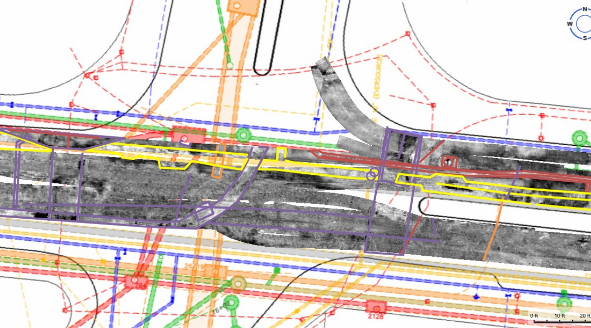
Showcasing Excellence: Our Success in Mapping College Campuses
DGT has partnered with a West Coast University to locate and map buried facilities and infrastructure to create a three-dimensional digital map of the school’s ever-evolving campus. Prior to working with DGT, the school had records of various parts of the property but no single source of truth for the campus’ underground environment. In our work with the university, we’ve provided 3D utility locating and mapping to begin the compilation of a master digital utility atlas.
Subsurface utilities are the nervous system of our campus and it’s vital that we protect them accordingly,” said West Coast University Asset Manager. “DGT has transformed the way we maintain and manage our utility assets. We can depend on their team to provide the utmost accuracy in every map they generate. With their help, we have a single source of truth to reference to ensure a safe campus environment no matter the improvements that need to be done.”
— Asset Systems Development Manager
Explore the Latest


Let’s Get Started
Contact us to learn more about our campus planning service offerings and speak with our underground utility mapping specialist.