Project Spotlight: Using Mobile Mapping Technology to Uncover Hidden Underground History at 470 Atlantic Avenue
Project Spotlight: Using Mobile Mapping Technology to Uncover Hidden Underground History at 470 Atlantic Avenue
Boston’s downtown waterfront houses some of the city’s most iconic and recognizable architecture. Over the past 300 hundred years, this stretch of the city has undergone significant development. Initially, Boston’s shoreline was dotted with piers and docks as the harbor posed an ideal sheltering port for the Atlantic trading routes and fishing boats. Yet over time, the wharf was slowly replaced by the city’s booming financial district and accompanying residential buildings. One notorious waterfront road that has been central to numerous changes is Atlantic Avenue, which stretches from South Station to Faneuil Hall. For decades, the Boston waterfront has been an ongoing site of development, and DGT has and continues to contribute to various projects along Atlantic Ave, one of the current ventures being 470 Atlantic Ave.
An Office Building with a History to Be Told
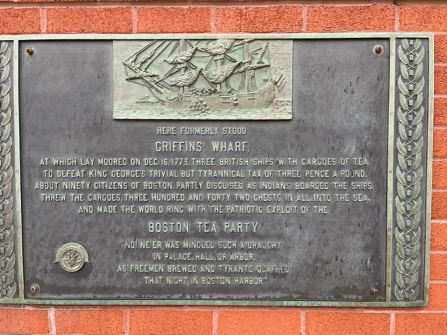
Neighboring South Station and the historic Boston Tea Party site stands a reflective waterfront 14-story building, Independence Wharf at 470 Atlantic Ave. Located on the Fort Point Channel, the building is a prominent link between Boston’s financial and seaport districts. Independence Wharf is currently comprised of private office and collaboration spaces, but the top floor is an observation deck open to the public. While many buildings in Boston serve similar purposes, none have the same unique history as 470 Atlantic Avenue.

Fletcher, Eric. “470 Atlantic Ave – Independence Wharf.” Loop Net, www.loopnet.com/Listing/470-Atlantic-Ave-Boston-MA/4425854/. Accessed Aug. 2023.
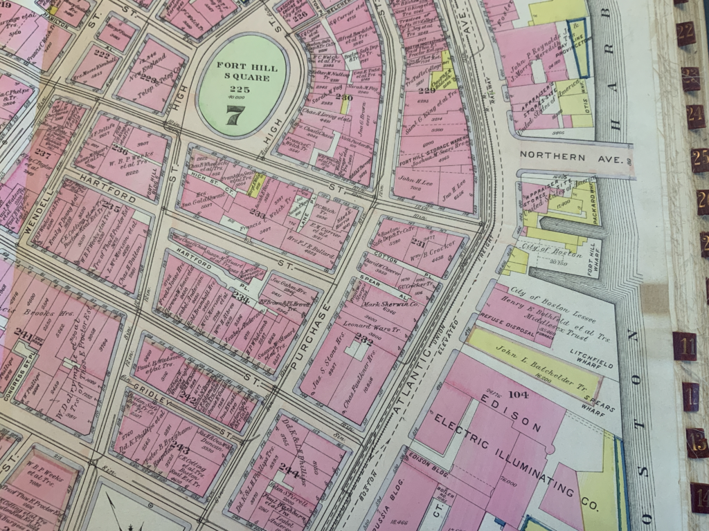
According to the Bromley Atlas, in 1908, Independence Wharf was also the building for a trash transfer station, noted as “REFUSE DISPOSAL” in the image below. In addition, 470 Atlantic Ave was also the site for Boston’s FBI Headquarters in the 1960s. During this time, the building was known as the Sheraton Building and accommodated 200 FBI employees. The division averaged nearly 3,000 cases a year, including civil rights violations, racketeering, gambling, and draft dodging. In 1996, the office grew to over 250 employees forcing the bureau to acquire a new space and move to the John F. Kennedy federal office building.
The Big Dig and its Adverse Implications
Atlantic Ave has earned a prominent place in Boston’s history, but the areas surrounding the building also have a unique story to tell—aiding as the center of Boston’s infrastructure growth. In the late 1950s, the Massachusetts Highway Department constructed the Central Artery, an elevated highway system dubbed Interstate 93. The highway was located in the heart of the city and connected to a tunnel system going southbound through South Station. Standing tall over the area, the highway was an eye-sore to the city and had a reputation for its terrible traffic, garnering the nickname “The Distressway.” Not only was Interstate 93 a headache, but it claimed territory along Atlantic Ave during its development, demolishing many significant buildings along the waterfront to make room for the new corridor.
In the late 1990s, the Federal Highway Administration and Massachusetts Department of Transportation began one of the nation’s most significant infrastructure projects, Boston’s Big Dig. The Central Artery carried upwards of 200,000 vehicles a day and was one of the busiest highways in the United States. To improve residents’ quality of life and disperse traffic throughout the city, Boston planned to rebuild the entire highway system underground. While the project improved the city’s traffic and aesthetics, it was also the most expensive highway project in the United States. It exceeded the initial budget by billions, and construction lasted over a decade.
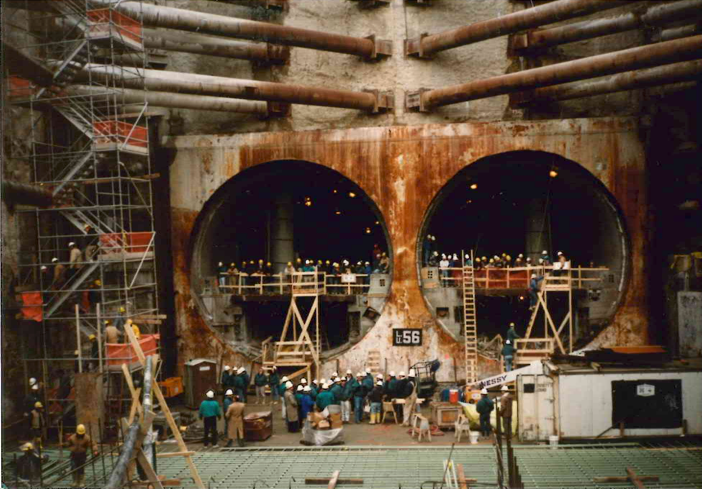
During the Big Dig, when the Artery was moved underground, and designers created a greenspace known as the Rose Kennedy Greenway, Atlantic Ave was partially relocated. The Greenway separated Atlantic Ave’s northbound and southbound traffic, splitting the road into two. Despite the extensive changes throughout the city, records were not kept nor updated, neglectfully omitting above and belowground infrastructure and utility changes. Critical details that could have been easily measured and marked on records are now incomplete and unanswered, making future construction projects in the area extremely complex. The implications of “lost” data from the Big Dig leave project planners and designers with little to no record of what utilities lie underground and how deep they are, increasing the chances of public harm, worker endangerment, higher project costs, structural damage, and, even impairing a firm’s reputation should a utility line be struck.
Uncovering Lost History
Today, DGT is working at 470 Atlantic Ave to complete a detailed subsurface map for a design and reconstruction team redeveloping the property. Constructing new utility connections and calculating the optimal location for heavy crane outriggers was a major consideration for the builders. With decades of undocumented change above and below ground, the project presents a unique set of challenges. During investigations, DGT’s subsurface mapping team uncovered various findings, including locating a maze of utilities compressed onto the sidewalk and around the building’s foundation, underground areaways, vaults, abandoned chambers, and plazas built on footings over Fort Point Channel. In addition, DGT mapped an unknown structure from a forgotten era of piers and docks. Finally, just feet from the front of the building, DGT pinpointed the primary slurry wall locations used by the Massachusetts Highway Department as foundation elements while constructing the underground Central Artery. These primary walls are the outermost structural foundation elements of the Central Artery Tunnel that run the length of Atlantic Ave. Since many key highway foundation elements required a significant portion of the underground space in Atlantic Ave, most public utility systems had to be relocated and rebuilt, making this underground very compressed.
With a longstanding presence in Boston, DGT has mapped projects in the seaport to Fenway Park and everything in between. The underground data we collect and provide clients is critical to the success, safety, and efficiency of construction projects. It also builds DGT’s institutional knowledge of the city and prepares us for future infrastructure changes. As our work at 470 Atlantic Ave comes to a close, we’re excited to see the new life it brings to the city and the rich history it adds to the reputable Atlantic Ave.
Learn more about DGT’s Subsurface Utility Mapping (SUM) services.