From Marking to Mapping Blog Series
Urban Hieroglyphics: The Shortcomings of Paint and Mark-outs in Utility Mapping
Urban Hieroglyphics: The Shortcomings of Paint and Mark-outs in Utility Mapping
Urban Hieroglyphics: The Shortcomings of Paint and Mark-outs in Utility Mapping
Communication through written symbols dates back centuries, to when the ancient Egyptians introduced hieroglyphics. Scribes carved inscriptions into buildings, tombs, and temple walls that represented different sounds, ideas, and even philosophies. Due to the intricacy and complexity, specialized training was required to read and understand hieroglyphics.
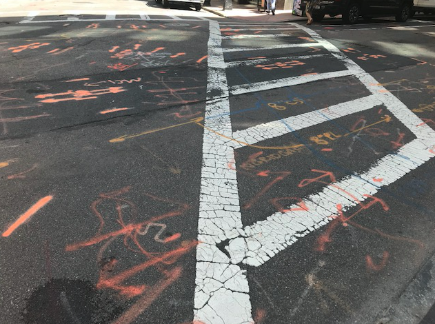
Although we no longer see hieroglyphics etched into the sides of buildings, we do see a new form of urban hieroglyphics painted on sidewalks and streets—utility paint marking.
Just like the hieroglyphics, utility mark-outs—multi-colored lines, arrows, and diamonds—intend to communicate messages to a specialized audience. Underground asset owners, utility locators, and survey professions inscribe and interpret the markings to determine the estimated locations of underground utilities. However, in an increasingly digital environment, the value and shelf life of mark-outs is diminishing as development transitions to 3D.
The History of Marking Underground Utilities
In 1969, a terrible gas line explosion in Culver City California set off a chain of events that resulted in four fatalities and numerous injuries. The root cause of the tragedy was a mismarked gas line on a construction site. The paint was off by only 18 inches, but that small margin of error was the difference between life and death.
As similar incidents arose around the country, new federal laws surfaced to prevent future tragedies, improve excavation practices, and hold asset owners accountable for accurately painting and marking their facilities. Shortly after the Culver City tragedy, the American Public Works Association (APWA) published the Uniform Color Code for Marking Underground Facilities, with both permanent and temporary designations, to help protect workers and residents from the risks associated with digging underground. Color-coding utilities became an accepted standard nationwide and was adopted internationally with countries using similar color nomenclatures.
Today, federal and state legislation requires that all parties involved in construction, on public or private land, communicate through paint on the ground. The mandate necessitates a multi-professional process. First, contractors and excavators pre-mark the area where they plan to dig with white paint or stakes. Next, they must inform their respective One Call, 811 centers, a free service which coordinates between utility owners and contractors, of their intent to break ground. The One Call center, referred to as DigSafe in New England, then generates an electronic ticket based on geographic locations and transmits it to all underground stakeholders in the proposed work area. The underground stakeholders can respond accordingly based on the existence and ownership of facilities in the proposed work zone, potential utility conflicts, protection needs of critical infrastructure, and risk associated with working on or nearby a particular facility.
The Pitfalls of Paint Laws
The 811 laws and processes are in place to encourage communication beyond the paint. However, certain stakeholders are granted exemption from these laws. For example, privately owned utility companies, municipalities, railroads and state DOTs typically can circumvent mandated damage prevention processes. Due to these exclusions, project areas often have buried facilities that are not painted or flagged even after the One Call ticket is obtained; an estimated 65% of all buried facilities are privately owned.
While not exempt from damage prevention laws, homeowners breaking ground on private property commonly fail to understand the intricacies of DigSafe laws, negate a One Call ticket altogether, or fail to follow through after DigSafe confirms its preliminary findings, increasing the risk of damage on their own property. On the other hand, some homeowners assume that the information gathered by DigSafe about the subterranean infrastructure is simply enough. Unaware of the statewide exemptions, they opt to save time and money and map their design with only the information gathered from the preliminary discovery.
Flawed laws aside, painting the ground also poses another challenge: flat data. Owners, designers and contractors may be able to see where a line is—provided the marking is accurate—but they can’t take the information the paint provides with them in order to make sound decisions; there’s no metadata attached. The precise location is not the only important information for contractors, owners, and designers to know when working underground. The age, condition, and ownership of the facilities matter too.
Just last month, a major water main break in Houston was not due to contractors striking the line, but rather from digging around it. Though they knew where the line was, the line’s condition was unknown. As it turned out, the line was being held together by the pressure of the earth around it. Once the contractors disrupted its support system, the line blew, putting the entire city of Houston on a water boil notice for more than a day’s time.
With loophole laws, widespread unmarked utilities, and lack of critical information, stakeholders cannot rely on paint alone to perform safe work and carry out successful projects.
Going Above the Law
To mitigate these risk factors, contractors, utility companies, homeowners, and even painting professionals must go beyond the legal standards of marking with paint and flags, and use comprehensive, 3D Subsurface Utility Mapping (SUM) to locate and map buried facilities.
In an industry where painting utility hieroglyphics is the norm, DGT challenges the status quo. We believe that the end result of utility locating should provide accurate plans and detailed maps that allow stakeholders to make informed decisions about construction and design.
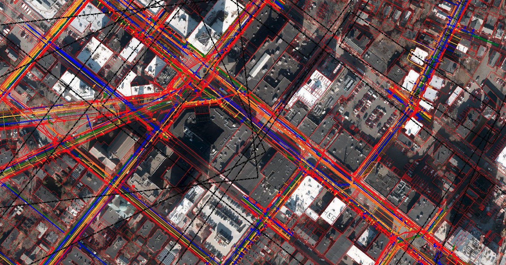
Our team of utility mapping professionals embrace modernization and use Subsurface Utility Mapping (SUM) to capture a complete picture of the underground environment. SUM digs deeper into locating underground utilities, by creating color-coded 2D and 3D digital delivery formats to depict and map the underground location of the critical infrastructure that can be delivered in Computer Aided Design (CAD), Building Information Modeling (BIM), or GIS formats. SUM allows professionals to gather metadata which enriches the design of a site that simple paint markings could never provide.
By combining data gathered from SUM in conjunction with historical records we’re able to mitigate the risk of striking undocumented utilities, as well as improve project execution, and minimize changes and claims. Through integrating technologies that advance surveying services, DGT is able to leave behind ancient unintelligible techniques and foster innovation in the field of surveying and engineering.
This article is part of a series “From Marking to Mapping,” in which DGT shares our view on best practices for locating, mapping and ultimately protecting underground utilities. Check out the next blog in our series titled, “Improving Upon Our Dig Laws: Recognizing Inadequacies.”