Surveying and Scanning for Forensics: Uncovering the Truth One Measurement at a Time
Surveying and Scanning for Forensics: Uncovering the Truth One Measurement at a Time
The role of a surveyor is pivotal to the success of projects spanning across a variety of industries. Surveyors gather precise measurements to establish an accurate lay of the land and map the world around us. These skills not only apply to assessing conditions for future and current sites, but also evaluating past sites conditions.
The process of analyzing past conditions is known as forensic surveying. When you hear ‘forensics’ you may be transported into your favorite crime drama, but ‘forensic surveying’ is a bit different than what you’d expect to see watching CSI Miami. Forensics relates more broadly to investigating scenes and situations to piece together a series of events and determine what actually occurred. And for surveyors, who are experts in gathering data and measurements, recreating situations utilizing modern technology and precise measurements is in their DNA.
The Process of Surveying and Scanning for Forensics
There are many scenarios that could warrant a forensic survey. Typically, forensic surveys are initiated by lawyers and insurance companies when property damage or injury has occurred. These scenarios could include a railroad collision, construction accident, escalator incident, or something as simple as a fall in a grocery store parking lot. Any scenario where litigation may occur typically calls for a forensic survey where surveyors capture the scene before it gets disturbed. Capturing a site before it’s disturbed creates a more accurate picture of the scene, which helps lawyers prove their case and ensures the correct party is held accountable. On occasion, there are instances where surveyors are called in after the scene has been cleared, but more commonly, our work begins almost immediately after an incident.
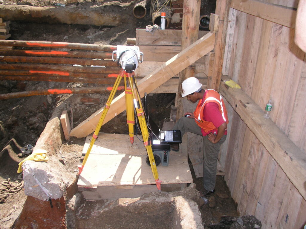
While our work is leveraged by lawyers settling a claim or as evidence in court, surveyors are usually hired by a forensic engineer leading the investigation. When we arrive on site, we’re able to assess and establish the best process for gathering site conditions based on the conditions of the scene. Simpler cases call for traditional surveying methods with a total station while more complex sites require 3D scanners to capture a 360 degree picture.
After we’ve collected measurements and captured the scene conditions, our team will interpret the data and present the findings to our client. While the final deliverable is customizable to each client’s needs, we’re able to provide point cloud scans, a detailed site plan, and a comprehensive report with measurements, sketches, and more. Additionally, we’re able to create theoretical scenarios that show what could or should have been in place to make the scene safer. The 3D data we’re able to provide captures far more than basic photographs and creates a real-life image of the scene in question. Armed with the detailed information we provide, lawyers can better prove their case to ensure companies or individuals are held accountable and victims are fairly compensated.
Reflecting on Scenarios in the Field: Electrical Wire Accident
Over the years we’ve completed a wide variety of forensic surveys. Since the circumstances around forensic surveying differs drastically for our typical day-to-day work, these retroactive investigations often stand out.
During one of our earlier forensic surveying cases, we were hired to investigate a scene north of Boston where a carpenter had been badly electrocuted by wires on a pole parallel to where he was working on a roof. When we arrived on the scene, an electrical engineer who was hired by the carpenter’s lawyer guided us through the scene and explained what had happed. In his preliminary assessment, he believed the cause of the accident was sags in the wire. With this information in mind, our team got to work. We performed a survey and 3D scan of the house, poles, and surrounding area. In particular, we focused on the pole that was next to the house where the carpenter was electrocuted and compared it to the pole on the other side of the house. Using sophisticated scanning technology, we were able to show that the wire was too close to the house and, furthermore, that the reason they were so close to the house was because the pole was leaning—an apparent violation by the utility company.
Accident Scene Survey
Existing Wires - Plan View
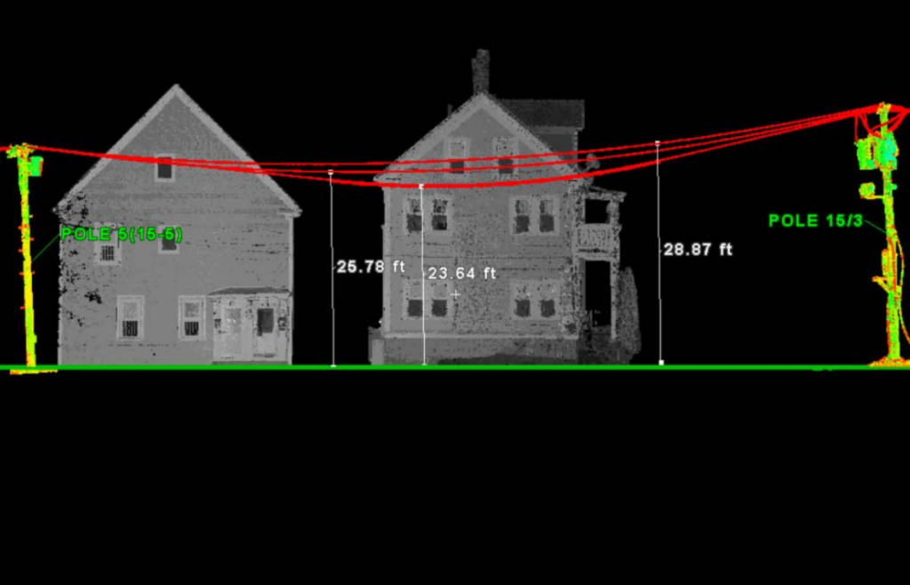
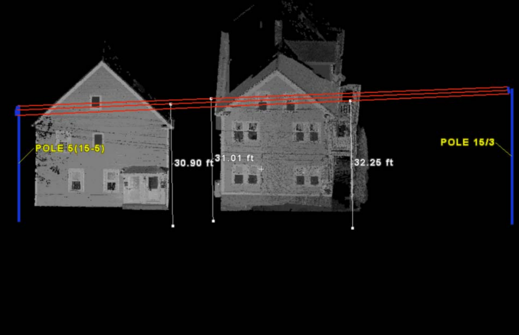
If we had only performed a traditional survey, using our total station, we would have drawn a line from the base of the pole next to the house to the base of the pole across the street. This would have neglected to show that the top of the pole next to the house was in a different location than the bottom of the pole. In addition to providing the scans to the client, we created a theoretical scenario to show what the site would have looked like if the pole had been straight. That scenario proved that if the pole had been straight, the wires would not have been in violation and the carpenter could have avoided injury. This case clearly showed us the power and benefits of modern scanning technology.
Accident Scene Survey
Theoretical Wire - Measurement to Ground
Reflecting on Scenarios in the Field: NY Explosion
Another significant forensic survey investigation led by our team involved a manhole explosion that occurred in New York City near Grand Central Terminal. DGT was called in urgently in the middle of the night to capture the scene with 3D scanning. Since this explosion occurred at a major intersection, affecting various utilities, the situation needed to be resolved immediately. Yet before repairs could take place and the hole could be filled in, the city rightfully wanted to capture evidence.
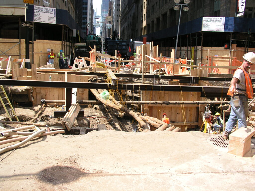
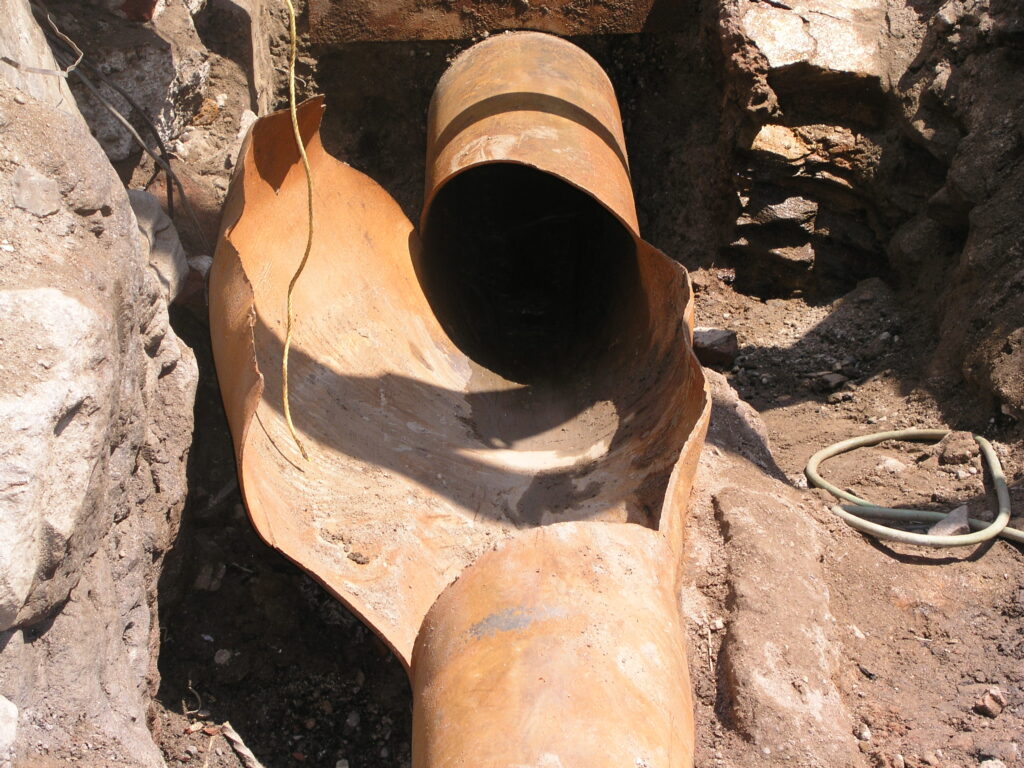
Due to the complexity of assessing a scene with various underground layers, these scans took a few days to complete. It was later determined that the explosion was caused when a steam pipe burst due to exposure to cold water.
Reflecting on Scenarios in the Field: University Laboratory Slurry Walls
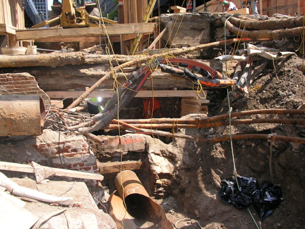
When reflecting on forensic surveys that we’ve completed in the heart of Boston, our work on the campus of a major university in Cambridge, Massachusetts comes to mind. Slurry walls (temporary underground walls) are a common construction technique used in populated cities, like Boston, because they allow developers to avoid building invasive trenches in a condensed city. These structures were used in the building of the Big Dig and are commonly used in development of high rises, especially for those with underground garages. Once the slurry walls are in place, a rebar cage is positioned in the trench and concrete is pumped from the bottom up, pushing out the slurry and forming a concreate wall.
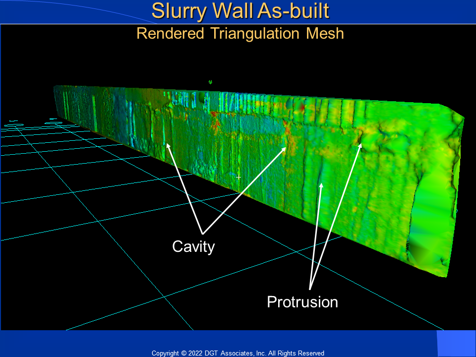
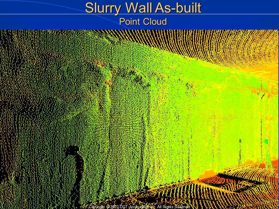
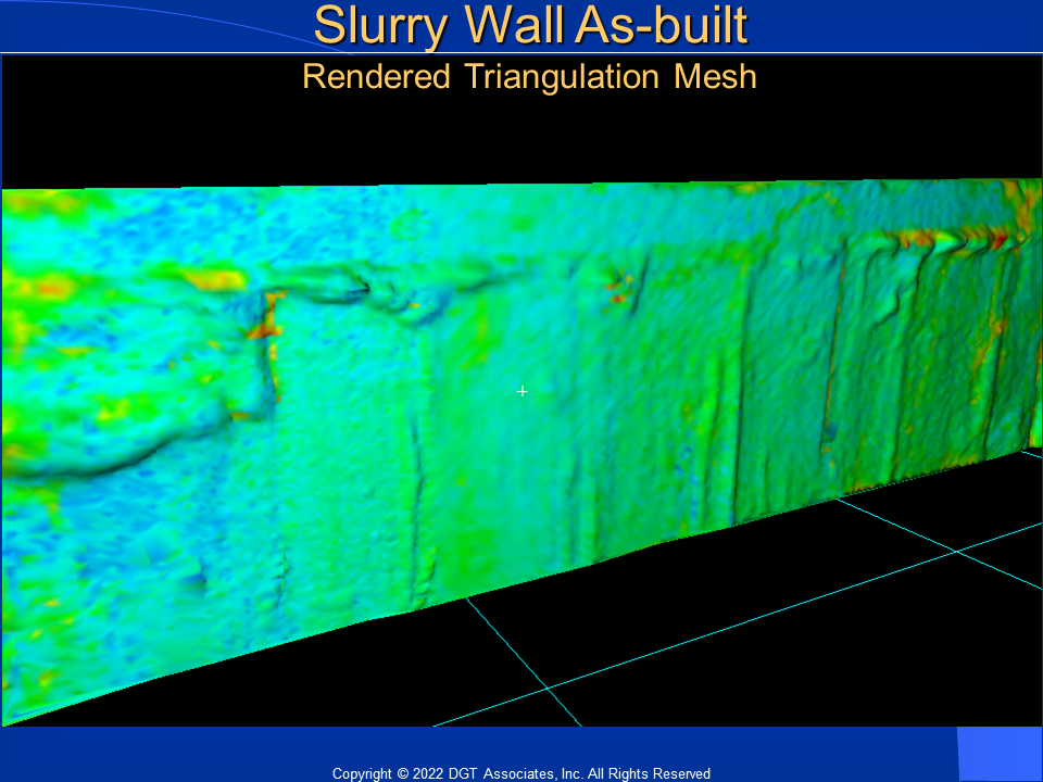
In this case, the university was developing an underground laboratory on campus and hired a construction company to spearhead the project. The construction company used slurry walls, however, when then concrete was filled, the project’s Geotech consultant noticed that the walls were out of tolerance—meaning chipping would have to be done to remove the excess. With the cost of underground space being so high, and the need to make use of every square foot of the underground laboratory, the owner wanted the walls fixed. When a disagreement struck between the construction manager and the concrete subcontractor, DGT was brought in to perform a 3D survey and determine who would be responsible for paying for the wall repairs. Through our instrumental work, we concluded that the construction company was at fault. That particular owner has subsequently implemented a standard making 3D surveys a standard specification for all construction involving slurry walls moving forward.
In the Court of Law
When comparing boundary surveys and forensic surveys, there are many parallels. However, the key difference is that forensic surveys stand in the court of law to provide legal theories and evidence. While the forensic cases DGT has supported have not resulted in a court case, as licensed land surveyors, we’re able to testify in the court of law as expert witnesses. Our testimony would endorse the accuracy, level of precision, and measurements taken on site. In other words, we’re able to offer the court a clearer understanding of the scene with details and dimensions going far beyond what can be captured in a standard photograph. While many professionals perform forensic surveys, having a surveying or engineering background like our team at DGT provides an incomparable advantage in this work because of the inherent understanding of tolerance and accuracy, as well as our expertise leveraging modern scanning technology.
To learn more about how DGT can support your next project, check out our surveying services.