Better Information, Faster: The Latest in Mobile Subsurface Utility Mapping
Better Information, Faster: The Latest in Mobile Subsurface Utility Mapping
In Sydney, Australia, a new light rail project has been anything but light. Those involved in the work say the project is billions of dollars over its cost estimate and years delayed, with no end in sight. Closer to home, the recent Los Angeles 405 highway project resulted in a settlement of $300 million dollars. The reasons? Inadequate underground utility information.
The Underground Challenge
In many parts of the US, the underground infrastructure is more than 150 years old. In other parts of the world, the facilities are even older. Although underground facilities were designed to provide reliable service, many of the buried pipes we rely on today are well past their intended design life.
Additionally, growing populations and a cultural shift to live inside metropolitan areas have increased the demand on our vital infrastructure and raised the stress on existing systems to meet the demand.
The solution seems simple: refurbish and rebuild. Yet, the American Water Works Association (AWWA) estimates that it could cost one trillion dollars to repair and replace the water systems in the US – just one of the utility systems beneath our feet.
With these challenges in mind, it is time for owners, designers, engineers and surveyors to have a paradigm shift in the way we map, locate and design projects to mitigate the financial risks and project delays when building projects in urban environments. Fortunately, with the latest advancements in subsurface utility engineering (SUE) and mapping (SUM), we can.
More Accuracy at Higher Speeds
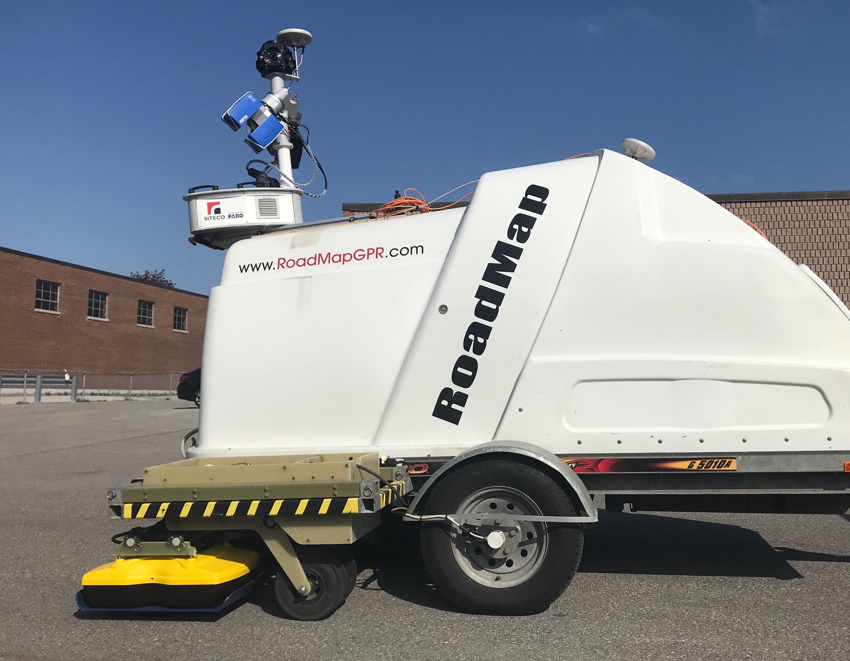
In recent years, the DGT team has been working to advance mobile mapping systems to integrate above- and below-ground remote sensing systems into a single, street and highway-ready mapping platform.
The system we’ve developed and tested, with our partners at SITECO and Sensors & Software, allows for the simultaneous roadway speed data collection using mobile lidar and Ground Penetrating Radar (GPR) with multiple antennas and different frequencies. It is mountable on a vehicle and collects both data sets at posted speed limits up to 65 mph, enabling professionals working in energy, transportation and asset owners to capture high-quality geospatial data without disrupting public life in urban areas. A key feature of the system is the ability to add other remote sensing technologies such as thermal imaging, road imaging systems and road profilers.
The system significantly cuts survey time, but also creates a safer work environment. On average, a work zone crash occurs every 5.4 minutes, with 70% resulting in property damage and 26% resulting in injury. With the mobile road scanner, there is no need to have crew members standing in live traffic, at risk of injury or death.
More Data with Deeper Analysis
With our system, improved data acquisition leads to improved data processing. DGT Associates’ SUM team, led by Director of Subsurface Utility Mapping, Michael Twohig, has focused on mapping the data collected in useful, digestible visualizations and analysis for designers.
“The value lies in the mapping,” said Twohig at a recent presentation of the system’s results at the SPAR 3D conference and expo. “In these early projects stages, design and development professionals need data they can immediately use.”
DGT packages the information not only into computer-aided design (CAD) files, but also into the more robust Geographic Information Systems (GIS) files that allow for deeper analysis and integration with non-spatial information. Interacting with GIS models, designers are able to mitigate risk by identifying potential conflicts with underground utilities, integrating costs and schedule, and forecasting future conditions.
By improving data acquisition and data processing, our goal is to create a viable workflow for mass data collection and virtual data analysis in a safe office environment for design and development professionals. Site investigations and recommendations can now be delivered in a matter of hours and days, not weeks and months.
Owners and engineers armed with more comprehensive data and actionable analysis at faster speeds can make more accurate design decisions for budgets, schedules and mitigating subsurface conflicts. With better-informed decisions, we can avoid situations like Sydney and LA.